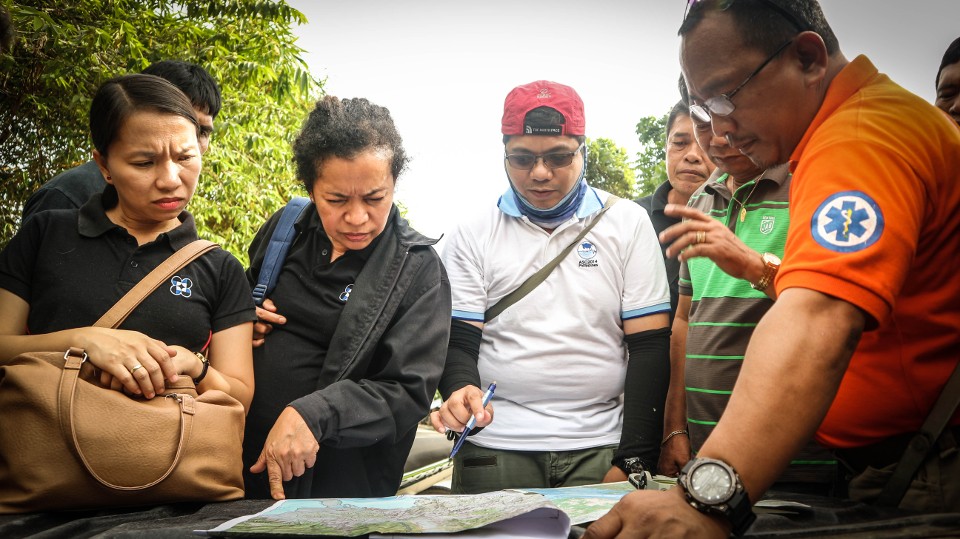
 Crossing the Davao Oriental-Compostela Valley border, the geologists show the provincial team the fault lines located in Brgy. Araibo in Pantukan, Compostela Valley. (Karen Deloso)
Phivolcs maps out fault lines in Davao Oriental

Crossing the Davao Oriental-Compostela Valley border, the geologists show the provincial team the fault lines located in Brgy. Araibo in Pantukan, Compostela Valley. (Karen Deloso)
A team of geologists from the Philippine Institute of Volcanology and Seismology (Phivolcs) have mapped out fault lines in earthquake hotspots here during a three-day activity dubbed as “Walk the Fault.”
Walking along the fault lines and planting markers above them, the activity aims to save lives by making residents and local officials inculcate a culture of safety, telling them to be aware on the location and trace of the fault lines especially those underneath settlements that might drastically be affected by massive earthquakes.
The team, who were joined by personnel from the Provincial Government’s Disaster Risk Reduction and Management Office with and other partner agencies that include the Department of Science and Technology, Department of Education, and the Davao Oriental State College of Science and Technology, among others, explored the areas and learned some interesting findings.
During the activity’s exit conference on Friday, January 19, the team headed by Geologist Jeffrey Perez revealed that based on their previous studies, there are some portions in the City of Mati and Lupon town which turned out to be sitting on top of the Philippine Fault line. These areas transected by fault lines include some mountainous portions of the villages of Marayag, Calapagan, and Don Mariano Marcos in Lupon town; and some portions in the villages of Taguibo, Sainz, and Central in the City of Mati.
With the fault line markers planted, sitio and barangay officials who joined the team noted the faults’ location in order to warn residents living above or near the faults to make necessary precautions and make pro-active preparations within their homes and communities.
While there are no fault lines found in densely populated and bustling business centers in the City of Mati, nevertheless, everyone is being cautioned as the areas where there are no fault lines are far from being safe from the hazards of earthquakes. Among these hazards include ground shaking which commonly results in the destruction of buildings, posing a great threat for injury and fatalities. Another common earthquake hazard is liquefaction which causes foundations and supports of infrastructures to sink. Earthquakes also trigger other hazards such as landslides and tsunamis.
“The fault here in Davao Oriental which is approximately 30 kilometers long is connected to the Philippine Fault line – the longest fault in the Philippines that stretches up to 1,200 kilometers from Luzon down to Mindanao, 320 kilometers of which are located in Eastern Mindanao stretching from Surigao area to the City of Mati,” he explains.
While larger magnitude earthquakes are observed when longer faults move, he says that the fault line in eastern Mindanao is divided into segments, which means they do not move at the same time. Citing one scenario, Perez said that “the movement of the 60-kilometer fault from Compostela Valley going to the City of Mati can result in a 7.1 magnitude quake”. However, most earthquakes in the City of Mati occur offshore.
PREPARATION
Amid the threat of earthquakes, authorities stressed that disasters can be mitigated with proper preparation and by taking necessary precautions. While earthquakes cannot be predicted, experts urge people to raise their awareness.
Perez emphasized laying a strong foundation for all kinds of infrastructure such as roads, bridges, and buildings. He says buildings can withstand an 8.0 magnitude quake as long as they are built according to the standard, have good structural integrity, and are constructed away from the fault lines.
Fault lines which are considered as danger zones are classified as no-build zone areas. He underscored the significance of the enforcement of strong policies such as establishing buffers of at least 5 meters on each side of the fault before constructing any structure. Strict observance of building code and responsible issuance of building permits are also strongly recommended. He further advised the inventory of the buildings and the conduct simulations to determine the possible damage.
Governor Nelson L. Dayanghirang, who requested the activity to be conducted here, emphasizes mitigation and preparedness as key factors to help save lives and prevent the crippling effects of devastation brought by natural disasters.
The Walk the Fault activity which prioritizes looking at fault lines in settlements and critical structures such as schools, barangay halls, churches, and roads, has been considered a significant step in disaster preparedness as it serves as an important tool in urban planning and development.
He underlined the activity as something that does not intend to cause alarm, but rather aim to promote awareness and safety to lessen damages and casualty when disaster strikes. (Karen Lou Deloso | Diocese of Mati)
No Comments